Bengaluru Metro Route Map Image With Place Name
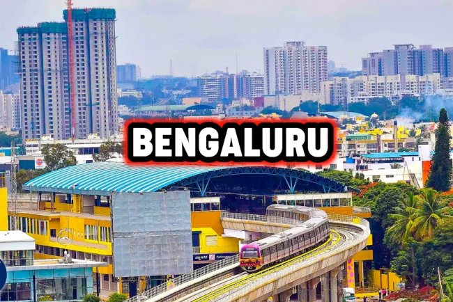
The Bengaluru Metro, also known as Namma Metro, is a rapid transit system serving the city of Bengaluru, India. It comprises two operational lines, the Purple Line and the Green Line, intersecting at Majestic station. The Purple Line runs east-west from Baiyappanahalli to Kengeri, while the Green Line runs north-south from Nagasandra to Silk Institute. Future expansions include the Yellow, Pink, and Blue Lines, aiming to enhance connectivity across the city and reduce traffic congestion.


Bengaluru the City that connects with a huge number of IT/ITES developments, swanky malls, multiplex, and many other lifestyle aspects has its metro services. The city has come up with its metro services as “Namma Metro” or “Bengaluru Metro”. The metro developments serve immediate connectivity and are the best infrastructure developments. The construction of metro services in the city was an initiative by the Government of India and the State Govt of Karnataka. The Bengaluru Metro or Namma Metro is by Bengaluru Metro Rail Corporation Limited or BMRCL.

Needs for metro services in Bengaluru:
The main objective behind the metro rail introduction is to cater to the needs of people and with the easing of traffic pressure on the roads. The making of the metro line also encourages travelers that start using public transport. It helps people to avoid personal vehicles that lead to congestion on roads. The metro system within the city is considered to be with complimentary transit mode. It will help with reducing the consumption of fuel to check pollution.
Bengaluru metro rail connects with the IT hub of India. With the Government initiative, it has got its metro rail. It was inaugurated in the year 2011 and has picked up with the completion of Mysore Road to Kangeri (reach 2) and (reach 4). Yalachenahalii towards Anjanapuratownship. Operation of Reach 3, 3A ( Penny Industry to Mantri Square Sampige Road station. The construction began on 1 March 2014. With the completion of the entire project, the Bengaluru Metro also known as Namma Metro. It is one of the fourth largest operational metro networks within India.
Two operational lines: Purple and Green have a total of 51 stations with a composite length of 72.17 km.
It adds 6 under construction lines that connect with 88 stations with a composite length of 99.296 km.
Bangalore metro has recorded with ridership of more than 6.88 lakh passengers on average per day in December. The much-awaited purple line of Bangalore Metro that runs between Chellaghatta& Whitefield is now operational. Additionally, BMRCL also has come up with land acquisition for Phase 3.
Bengaluru Metro will also come up as 2nd metro system in India that employs ATO Technology. It comes up on the upcoming Yellow line. It has come up with innovative services such as Group QR. It also increases with the attractiveness of Bengaluru Metro which comes as a First Choice Transport system for a city with huge traffic congestion.
BMRCL is the governing body that comes as Bengaluru Metro which is a joint venture of the Government of India, Govt of Karnataka.
Phase1 of Bengaluru Metro:
The total cost of the project is a huge amount of Rs 11,609 Crore. It connects with a total station of 41. The total distance under the project is 42.42 km. It has a total number of corridors of two. Corridor 1: Purple Line connects with Baiyyappanahalli – Mysore Road. It covers a total length of 18.22 km. The project covers huge number of station as 17.
The stations are Baiyyappanahalli – Swami Vivekananda Road – Indiranagar – Malasaru – Trinity – Mahatma Gandhi Road – Cubbon Park – VidhanaSoudha – Sir M Vishvesaraya – Majestic – City Railway station – Magadi Road – Hosahalli – Vijaynagar – Attiguppe – Deepanjali Nagar – Mysore road.
It comes with total length of 24.20 km. It adds with covering 24 stations on it.

The various stations are Nagasandra – Dasanahalli - Jaiahalli – Peenya industry – Peenya – Goraguntepalya – Yeshwantpur – Sandal soap factory – Mahalaxmi – RajajInagar – Kuvempu Road – Srirampurea– Sampige Road – Majestic – Chickpet – Krishna Rajendra Market – National college - Lalbagh – Southend Circle – Jayanagar – RashtriyaVidyalaya Road – Banashankari – Jayprakash Nagar – Yelachenahalli
Phase II by Bengaluru Metro
The total cost of the project is Rs 30,000 Crore estimated.
It has total station as 62 and the total distance of 73.291 km.
It has two corridors as Two New Lines and 4 Extensions.
New lines:
Corridor 3 is as Yellow Line: RV Road – Bommasandra
Total length is of 19.143 km i.e, elevated and covers total number of station as 16.
RashtriyaVidyala Road RV Road – Ragigudda – Jayadeva Hospital – BTM Layout – Central Silkboard – bommanahalli ( Formerly HSR Layout) – Hongasandra (Formerly Oxford College ) – Kudlu gate – ( Formerly Muneshwara Nagar ) – Singasandra ( Formerly Chikkabagur ) Hosa Road ( Formerly Basapura Road ) – BaratanaAgrahara – Formerly Hosa road – Electronic City – Infosys foundation station or KonappannaAgrahara – (earlier known as Electronic City –II) – Huskur Road station – Hebbagodi and Bommasandrastation
The status for the project is under construction.
Corridor IV – Pink Line – KalenaAgrahara – ( FormerlyGottigere ) – Nagawara
Total length for the project is 21.386 km. It is with underground and elevated station. The total number of covering stations is 18.
KalanaAgrahara ( formerly Gottigera ) – Hulmavu – IIM Bengaluru – JP Nagar Phase 4 – Jayadeva Hospital – Swagath Road Cross – Dairy Circle – Lakkasandra (Formerly Mico Industries ) –Langford town – RashtriyaMillitary school – ( Formerly Velarra Road ) – MG Road – Shivaji Nagar – Cantonment – Pottery Town – Tannery Road – Venkateshpura – kadugundanhali and Nagawara.
The project status is under construction.
Extensions:
Line 1: Purple Line – Mysore Road
Total length is 8814 km i.e. on elevated corridor. It covers total number of station is 7.
Nayandahalli – Rajarajeshwarinagar – JnanaBharathi (Formerly Bangalore University Cross) Pattanagera – Kengeri Bus terminal ( FormerlyMallasandra ) Kangeri and Challeghatta
The status for the project is operational.
Line 01 : Purple Line: Baiyyappanahalli – Whitefield
The total length for the project is 15,257 km. It isan elevated corridor. The total number of covering station is 13.
Benniganahalli – KR Pura – Singayyanapalaya – Gurudacharpalya – Hoodi – Seetharamapalya – Kundalahalli – Nallurhalli – Sri SathyaSai hospital – Pattandur – Agrahara – Kadugodi tree Park – hopefarmChannasandra and Whitefield (kadugodi )
The status is operational for this project.
Line 2 : Green Line : Yelachenahalli (Puttenahalli) – Silk Institute – (Anjanapura )
The total length for this project is 6.29 km. The total number of station is 5.
Doodakailasandra (Formerly Krishna LeelaPark ) – Konnakunte Cross ( Formerly known as Anjanapura Cross Road ) – Vajrahalli – Thalgattapura and Silk institute which is formerly known as Anjanapura Township and Anjanapura
The status for the project is inaugurated on January 14, 2023.
Line 2: Green Line –Yelachenahalli oralso known as Puttenahalli ) – The Silk Institute Station oralso known asAnjanapura )
The total length for the project is 6.29 km that also o an elevated section.
It covers total of 5 stations.
Doodakallasandra( That is formerly known as Krishna park) - Konakunte Cross – That is formerly known as Annjanapura Cross Road ) – Vajrahalli – Thalgattapura and also the Silk institute – (which is formerly known as Anjanapura Township and Also Anjanapura )

The project got inaugurated on January 14, 2021.
Line 2: Green Line :Hesaraghatta Cross ( which is formerly known as Nagassandra ) – Madavar ( Or formerly BTEC)
Also Read :
The total length for the elevated corridor is 3031 km. It has total covering station as 3. The stations are Manjunathnagar, Chikkabidarakallu( formerly known as Jindal and Madavar that is formerly known as BIEC
The project status is under construction.
Here are the operational lines ( Ph 2, Ph 1)
Line 1: Purple line :Challaghatta – Whitefield ( Kadugodi ) at 42.17 km with 37 stations.
Line 2 on Green Line :Nagasandra and up to Silk institute with 30 km line on 29 stations.
There are few under construction lines on Line 2 as Green Line, Line 3 as Yellow Line, Line 4 as pink line, line 5 as ORR line and Line 5 as Airport line.